Bridging soil-plant-atmosphere dynamics with advanced Earth Observation
to address water accounting in the Mediterranean
PROJECT
Water Scarcity in the Mediterranean
Water scarcity is one of the most pressing challenges facing the Mediterranean region. Climate change, population growth, and agricultural intensification are putting unprecedented pressure on water resources.
TWISTT aims to improve transparency in water accounting by estimating soil evaporation and plant transpiration using multi-scale Earth Observation (EO) data and modelling approaches.
A Multi-Scale EO and Modelling System
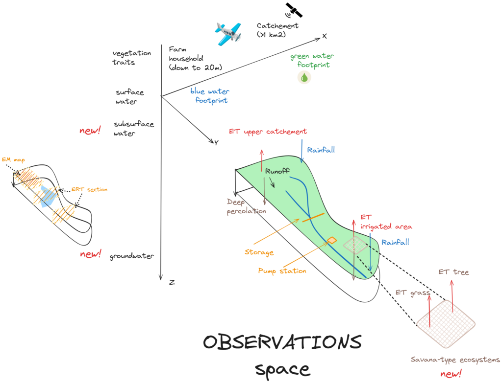
The TWISTT project develops an innovative multi-scale Earth Observation (EO) and modeling system to enhance water accounting in the Mediterranean. By leveraging data from the Copernicus EO program and Sentinel missions, the project will generate maps to estimate soil evaporation and plant transpiration.
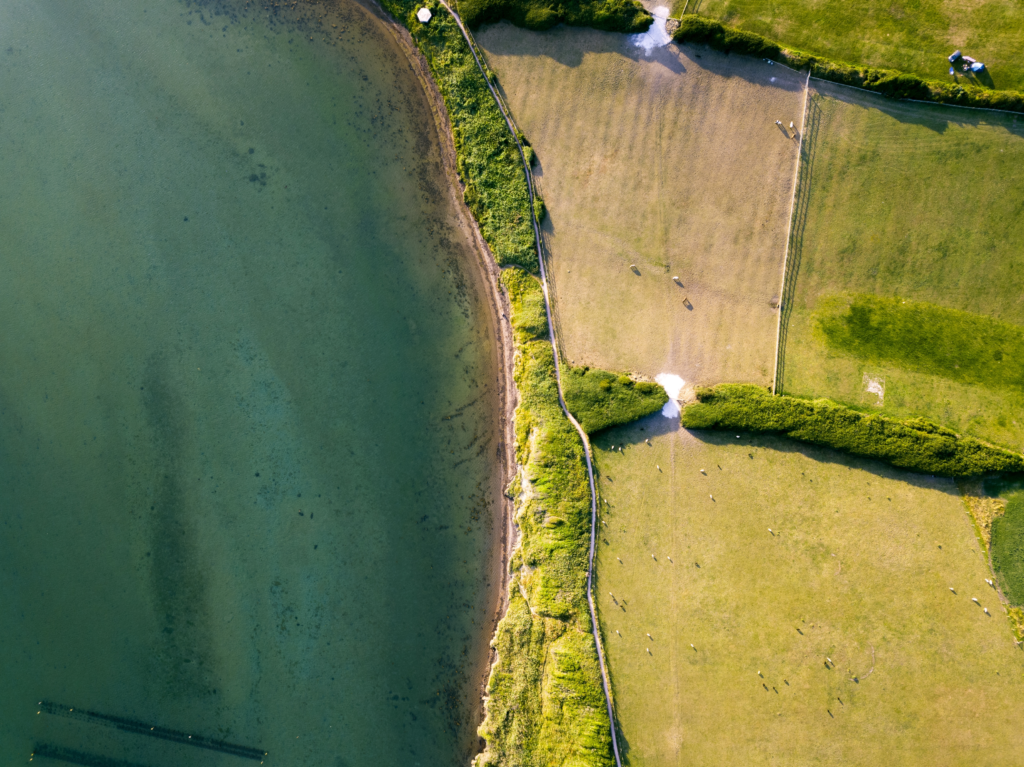
TWISTT also integrates geophysical techniques to observe subsoil characteristics and water flows, contributing to improved irrigation accounting and efficiency across agricultural systems.
ACTIVITIES
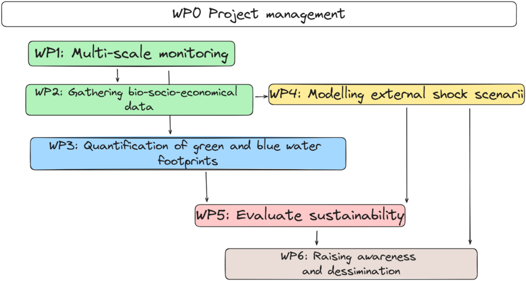
WP1
Coordination and Project Managemen
Coordination of partners, reporting, risk monitoring, ethics, administrative & financial management.
WP3
Geophysical Measurements and Subsurface Characterization
Airborne & ground-based geophysical surveys, mapping soil/subsoil layers, water-table depth estimation, identification of recharge areas.
WP2
Earth Observation Data and Hydrological Modelling
Development of multi-scale EO products, modelling of evaporation, transpiration and creation of water-use indicators.
WP4
Integrating EO + Geophysics + Modelling for Water Accounting
Integration of hydrological models, EO-based evaporation/transpiration, and geophysical subsurface parameters to distinguish blue/green water.
WP5
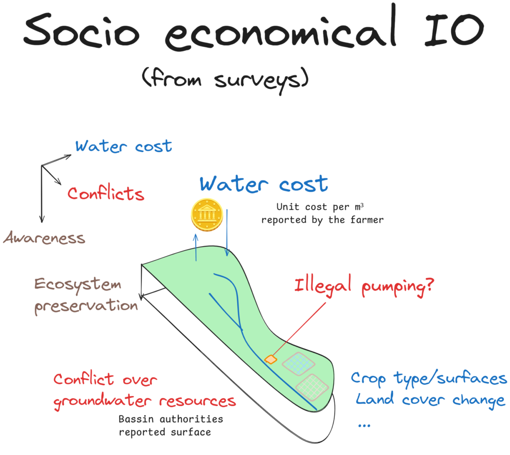
Socio-economic Scenarios & Water Management Strategies
Development of climate and socio-economic scenarios, stakeholder engagement, irrigation practices analysis, governance strategies.
WP6
Communication, Dissemination & Exploitation
Development visual identity, preparation of communication materials , organisation of workshops and outreach events, and engagement with stakeholders to ensure effective dissemination and uptake of project results
TWISTT works across four representative Mediterranean regions: Morocco, Tunisia, Italy and Spain to capture diverse climatic conditions, water distribution and management systems, crop types and socio-economic factors, providing a balanced geographic representation across the Mediterranean regions.
6
PILOT SITES
4
COUNTRIES
36
MONTHS
6
PARTNERS
1.5M
€ BUDGET
TIMELINE
A Mediterranean Partnership for Water Innovation
TWISTT project brings together a diverse consortium of international partners, combining scientific excellence, technological innovation, and institutional engagement to address the challenges of sustainable water management.
|
|

|
|
|

|
| Role: Scientific coordinator: Project coordination, remote sensing expertise, precision agriculture research, geophysical integration | Role: Technology & innovation partner: Airborne geophysical surveys, commercial exploitation, subsurface water mapping | Role: Research partner: Water-energy balance modeling (WP3), irrigation efficiency optimization, Italian pilot site coordination | Role: Research partner Multi-scale monitoring (WP1), geosciences and remote sensing, Moroccan pilot site coordination | Role: Research partner Sustainability evaluation (WP5), applied biology and biotechnology, field experimentation | Role: Research partner Socio-economic analysis (WP2), stakeholder engagement, policy interface |
| Expertise: Multi-scale Earth Observation, energy balance modeling (TSEB, 3SEB), geophysics for agriculture, experimental farm facilities | Expertise: 100+ years combined experience in natural resource mapping (water, energy, minerals), airborne geophysics, data processing and interpretation, business model development | Expertise: FEST-EWB model development, integration of satellite data with hydrological models, precision irrigation management | Expertise: EO data fusion, geospatial analysis, GIS, environmental monitoring, stakeholder engagement in Doukkala region | Expertise: Crop physiology, soil science, irrigation strategies, farmer collaboration in Nador-Driouch region | Expertise: Production economics, farming system analysis, water resource governance, participatory scenario planning |
| Funded by | Funded by | Funded by | Funded by | Funded by | Funded by |
|
|
|
|
|
|
Coordinate by
TWISTT also works closely with:
- Environmental Organizations: Promoting awareness, sustainable practices, and ecosystem protection
- Research Institutions & Universities: Contributing advanced knowledge, validation, and technology transfer
- Farmer Cooperatives & Water User Associations: Ensuring solutions meet real-world needs and are adopted at scale
News & Events
- Advances field experiments on barley and table grapes in North-East Morocco
- Sustainable water irrigation management and socio-economic governance
- TWISTT asks farmers about new ways to managewater in the Kairouan region (Tunisia)
- TWISTT field campaign takes off in north-east Morocco: Drones over table grape and barley plots in Nador
- TWISTT Workshop in Tunisia: Day 1
- TWISTT Workshop in Tunisia: Day 2